
By The International Dark Sky Association, IDA
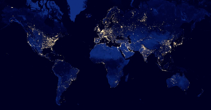 A composite image of the Earth at night made using data from the Visible Infrared Imaging Radiometer Suite (VIIRS) instrument aboard the Suomi NPP spacecraft. NASA photo.
Billions of people around the world routinely experience light pollution in the form of skyglow, the ever-present “haze” of light over cities at night. It comes from light on the ground scattering in the atmosphere and back to our eyes, blotting out the stars.
But some of that light manages to travel all the way through the atmosphere and escape to space. Earth-orbiting satellites intercept some of that light, and their cameras provide valuable evidence of not only where artificial light at night is used in the world, but how its changing. A variety of sources available on the web help dark skies enthusiasts around the world to access images from these satellites, and to better understand the light in their own local environments.
How Light Scatters Creating Light Pollution and Skyglow
The illustration below shows how some of the light we emit on the ground ends up in the lenses of cameras aboard satellites.
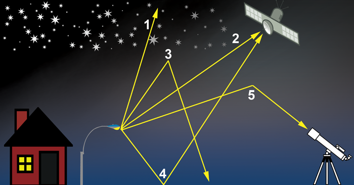
The streetlight emits light in many different directions. Some of the light rays (“1″) are directed up into the sky and travel completely through Earth’s atmosphere. Of these rays, a few (“2″) will be detected by satellites as they pass over the nighttime side of our planet. In still other cases (“3”), rays are scattered back to the ground by dust particles or molecules in the atmosphere, forming the familiar “skyglow” seen over cities. Occasionally, rays directed downward (“4”) reflect off the ground into the sky, where they might escape the atmosphere and be seen by satellites. Lastly, some downward-scattered rays (“5”) make it into astronomers’ telescopes, effectively blocking their view of the universe.
The amount of light detected by satellites is a good, basic estimate of the total amount of light emitted or scattered upward from the ground. If we make some assumptions about how much light comes back down to Earth as the result of reflection or scattering in the atmosphere, then we can work backward to figure out how much light must have left the ground. With this information, researchers can glean a lot of interesting information about humans’ use of light in particular, and about patterns of their global behavior in general.
The History of Light at Night Satellite Data
Some of the earliest artificial satellites, launched in the 1960s to monitor weather, could see the nighttime lights of Earth, but their cameras weren’t powerful enough to make scientifically useful measurements. Around the same time, the U.S. Department of Defense began its Defense Meteorological Satellite Program to gather weather information in support of American military priorities. During part of each orbit that a DMSP satellite makes, it’s in the shadow of Earth on the night side of our planet, where its cameras see not only clouds and continents, but also the lights of our cities.
In December 1972, the DMSP was declassified and its data were made available to the civil scientific community. Light pollution researchers immediately realized the value of this new data source. Models of how light travels through Earth’s atmosphere predict the fractions of that light will escape into space or scatter back to the ground, and DMSP images could be used as a crucial check of those predictions. At first, these checks were performed on individual DMSP images, which only showed a small part of the Earth at a time.
In 2001, a ‘World Atlas’ of artificial light at night was published, made from individual images taken on cloud-free nights without moonlight. Through careful calibration of the data and a model of how light is transmitted through the Earth’s atmosphere, the World Atlas yielded the first global measurements of the amount of human-caused light. However, because the purpose of the DMSP was to forecast weather, the cameras aboard DMSP satellites didn’t have the ability to see fine details on the ground. Many cities were seen simply as bright patches of light, without great detail.
More recently, in 2011 the U.S. National Oceanic and Atmospheric Administration (NOAA) launched the Suomi National Polar-orbiting Partnership, or Suomi NPP, satellite. Suomi NPP carried to orbit a camera called the Visible Infrared Imaging Radiometer Suite (VIIRS). This camera is equipped with some the best sensors and lenses ever flown on civilian space missions, and has transformed how we see Earth at night. Whereas the nighttime images from the DMSP satellites could see objects as small as about 3 kilometers in size, VIIRS can see objects smaller than 1 kilometer. As a result, we can see fine details such as highways and ring roads around cities. You can read more about the technical capabilities of DMSP and VIIRS here.
Read, Part 2 - Eyes In The Sky: Exploring Light Pollutin With satellite Maps
About IDA: The International Dark-Sky Association is a 501(c)(3) non-profit organization based in Tucson, Arizona. For more than 25 years, it has advocated for the protection of the nighttime environment and dark night skies by educating policymakers and the public about night sky conservation and promoting environmentally responsible outdoor lighting.
This article has also been published on the IDA Website.